Climate change

© Russian Arctic National Park news service

A receding Franz Josef Land: Archival photos help gauge the scale of melting glacier

Researchers from Russian Arctic National Park have gauged the pace at which the glaciers on Franz Josef Land are melting by comparing archival photos taken in different years.

"We were particularly interested in comparing the old and contemporary shots of the same locations taken from the same angle," says Yevgeny Yermolov, a historian and the Head of the Historical and Cultural Heritage Department at Russian Arctic National Park.

The park's staff managed to find shots taken by the American expedition led by Evelyn Baldwin, who disembarked on Alger Island in the central part of the Franz Josef Land archipelago on August 20, 1901. This moment was caught on camera by the expedition's photographer, Anthony Fiala. The photo shows the boat with travelers coming ashore, with two expedition vessels, the America and the Fridtjof, anchored in the strait in the background, while the snowcapped flat hills, or mesas, on Brady Island can be seen in the background.

Over a hundred years later, in August 2018, an archaeological expedition sponsored by Russian Arctic National Park worked on the same Alger Island. Its members took a photo of the strait from the same angle as the American expedition's photographer did.


Archival photos taken by Evelyn Baldwin’s American expedition (1901) and photos by the Russian Arctic National Park archaeological expedition (2018)
Archival photos taken by Evelyn Baldwin’s American expedition (1901) and photos by the Russian Arctic National Park archaeological expedition (2018). Archival photos taken by Evelyn Baldwin’s American expedition (1901) and photos by the Russian Arctic National Park archaeological expedition (2018)Archival photos taken by Evelyn Baldwin’s American expedition (1901) and photos by the Russian Arctic National Park archaeological expedition (2018)Archival photos taken by Evelyn Baldwin’s American expedition (1901) and photos by the Russian Arctic National Park archaeological expedition (2018)Russian Arctic National Park news service90/11/901175.jpg 901175 157 876 0 382 90/11/901175.jpg 901175 0 1500 0 382 90/11/901175.jpg 901175 271 749 0 382 90/11/901175.jpg 1 901175 221 771 0 437 90/11/901175.jpg 901175 167 831 1 382 90/11/901175.jpg 901175 190 818 1 382 90/11/901175.jpg 901175 244 761 0 382 90/11/901175.jpg 1 901175 172 832 -1 382 90/11/901175.jpg 1 901175 149 809 -44 382 90/11/901175.jpg 901175 232 614 0 382 90/11/901175.jpg 1 901175 143 803 -13 382 90/11/901175.jpg 1 901175 238 738 0 650 90/11/901175.jpg 901175 148 819 1 382 90/11/901175.jpg 901175 199 765 0 382 90/11/901175.jpg 901175 154 817 0 381 90/11/901175.jpg 1 901175 0 990 0 638 90/11/901175.jpg 901175 140 820 0 380 90/11/901175.jpg 901175 139 788 0 382 90/11/901175.jpg 901175 206 769 0 380 90/11/901175.jpg 901175 0 1500 0 383 90/11/901175.jpg90/11/901175.jpg


"It can be seen from the photos, which are 117 years apart, that the glaciers on Brady Island have different profiles," says Yermolov. "Although in late August 1901 the island was covered with snow, the landscape can be seen clearly. The contemporary photo shows that the rate of flow of the outlet glaciers has decreased notably over the past century. The old photo also shows the eastern coast of Brady Island, which is partly overlapped by the western coast of Matilda Island. The dome of ice sweeps gently into the water in the strait and its boundaries are not even seen in Fiala's photo. In 2018, a strait can already be discerned between the coasts of the two islands, while the glacial cupola is bounded by a rocky shore."

While sorting the photo archive out, the researchers also found shots from the 1930s — at that time a Soviet expedition on the ice-breaker Georgy Sedov landed close to Baldwin's camp. A Soviet flag made of metal was installed near the winter base camp. A few days later, Norwegian sailors arrived at the site aboard the vessel Bratwaag and took photos of themselves, with the Soviet flag and the American base camp in the background.

"The northern coast of MacKlintok Island can be seen in the background of the historical photo," says Yermolov. "A steep wall of ice is clearly seen behind the flagpole. In the 2018 photo, which was taken from the same angle, you can see a bay that in the mid-20th century Soviet hydrographers called Lednikovaya [Ice Bay]. By now the glacier has retreated further, making more room for the bay, and it cannot be seen from this angle. One can see clearly in the photo a vast expanse of cracks in the bay, which appear when an outlet glacier slides toward the sea. A bare Cape Dostupny is also seen clearly in the center of the contemporary photo, while in 1930 a significant part of it was covered by an outlet glacier. Now this glacier has a steep side."
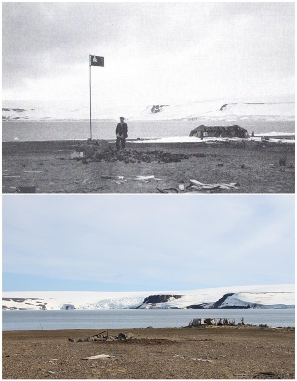
 

Archival photos taken by Norwegian sailors from the vessel Bratwaag, with a Russian flag with the American base camp in the background (1930), and photos by the Russian Arctic National Park archaeological expedition (2018)
Archival photos taken by Norwegian sailors from the vessel Bratwaag, with a Russian flag with the American base camp in the background (1930), and photos by the Russian Arctic National Park archaeological expedition (2018). Archival photos taken by Norwegian sailors from the vessel Bratwaag, with a Russian flag with the American base camp in the background (1930), and photos by the Russian Arctic National Park archaeological expedition (2018)Archival photos taken by Norwegian sailors from the vessel Bratwaag, with a Russian flag with the American base camp in the background (1930), and photos by the Russian Arctic National Park archaeological expedition (2018)Russian Arctic National Park news serviceArchival photos taken by Norwegian sailors from the vessel Bratwaag, with a Russian flag with the American base camp in the background (1930), and photos by the Russian Arctic National Park archaeological expedition (2018)90/12/901287.jpg 901287 21 1411 107 915 90/12/901287.jpg 901287 85 1371 105 935 90/12/901287.jpg 901287 0 1500 0 900 90/12/901287.jpg 901287 9 1490 0 1925 90/12/901287.jpg 901287 20 1211 80 885 90/12/901287.jpg 901287 28 1464 44 807 90/12/901287.jpg 901287 0 1500 0 1925 90/12/901287.jpg 901287 47 1222 22 961 90/12/901287.jpg 901287 47 1221 23 955 90/12/901287.jpg 901287 41 1374 134 901 90/12/901287.jpg 901287 67 1434 62 895 90/12/901287.jpg 901287 41 1281 41 956 90/12/901287.jpg 901287 24 1444 118 926 90/12/901287.jpg 901287 31 1449 54 871 90/12/901287.jpg 901287 23 1433 34 941 90/12/901287.jpg 901287 19 1463 33 845 90/12/901287.jpg 901287 15 1479 92 954 90/12/901287.jpg 901287 26 1419 18 963 90/12/901287.jpg 901287 0 1500 0 1926 90/12/901287.jpg 901287 0 1500 213 1713 90/12/901287.jpg90/12/901287.jpg

In a similar way, the researchers from Russian Arctic National Park compared the topographic map of Franz Josef Land to contemporary space shots. Soviet hydrographers carried out a topographic mapping of the archipelago in 1956-1958, after which a detailed map showing glaciers was made. Now the park has shots of Franz Josef Land taken from space, which show the current condition of the glaciers.

"Clearly, by the mid-20th century, when the topographic mapping was carried out, the size of the glaciers had declined," said Ivan Mizin, Deputy Director for Research at Russian Arctic National Park. "In the 1930 photo, Lednikovaya Bay off MacKlintok Island is completely covered by a glacier. As can be seen on the mid-20th century maps, the glacier significantly retreated and a deep bay emerged in its place. The 2018 space shot shows that the glacier has contracted further. In comparison with the topographic map, it has retreated approximately 1 kilometer into the bay."
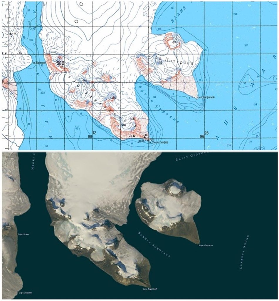
 

A topographic map of Franz Josef Land and a contemporary photo of the archipelago taken from space
A topographic map of Franz Josef Land and a contemporary photo of the archipelago taken from space. A topographic map of Franz Josef Land and a contemporary photo of the archipelago taken from spaceA topographic map of Franz Josef Land and a contemporary photo of the archipelago taken from spaceRussian Arctic National Park’s news serviceA topographic map of Franz Josef Land and a contemporary photo of the archipelago taken from space90/14/901403.jpg 901403 0 1500 0 796 90/14/901403.jpg 901403 0 1500 0 1614 90/14/901403.jpg 901403 0 995 0 795 90/14/901403.jpg 901403 0 1010 0 802 90/14/901403.jpg 901403 0 1389 0 798 90/14/901403.jpg 901403 0 1312 0 798 90/14/901403.jpg 901403 0 1066 0 787 90/14/901403.jpg 901403 0 1359 0 789 90/14/901403.jpg 901403 0 1205 0 780 90/14/901403.jpg 901403 0 753 0 753 90/14/901403.jpg 901403 0 1306 0 783 90/14/901403.jpg 901403 129 1370 0 1614 90/14/901403.jpg 901403 0 1393 0 793 90/14/901403.jpg 901403 0 1188 0 802 90/14/901403.jpg 901403 0 1385 0 798 90/14/901403.jpg 901403 0 1245 0 800 90/14/901403.jpg 901403 0 1415 0 795 90/14/901403.jpg 901403 0 1333 0 785 90/14/901403.jpg 901403 0 1179 0 800 90/14/901403.jpg 901403 0 1500 0 1616 90/14/901403.jpg90/14/901403.jpg

As evidenced by the comparison of the space shot and the topographic map, the outlet glacier in Brady Island, which was photographed by Anthony Fiala in 1901, has also diminished in size — it is clear that the glacier has retreated several hundred meters.

Links